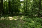
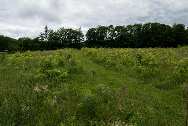
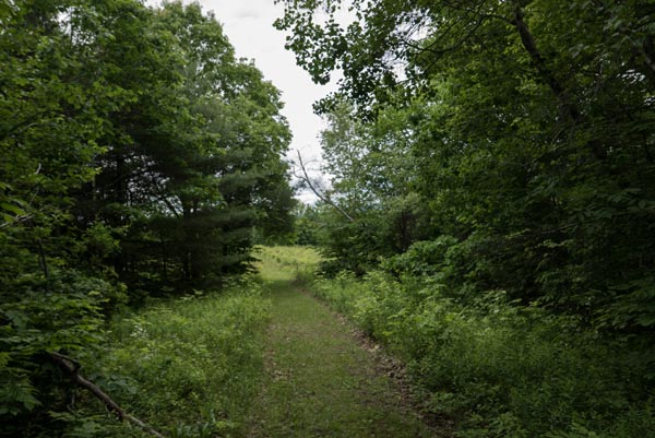
The Burke Family Wildlife Preserve is a 59 ac parcel in Deering on Pleasant Pond Rd, on Old Francestown Rd., just off Rt 149. The parcel, which is owned by the Piscataquog Land Conservancy, consists of open forest and marshlands. An informal trail (marked with blue diaonds) makes a short loop through the dry, forested part of the property. Dominated by hemlock and oak, this is a great trail for mushrooming! However, the largest part of the Burke Preserve is an extensive wetland with open water.
Entrance to Burke Family Wildlife Preserve. Photo by Gary Bono
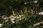
The Eversource power right of way that crosses Deering passes through the middle of the Burke Preserve. In 2016 Eversource undertook to replace the power poles in Deering. In order for them to cross the many wetlands in Deering between the Weare town line and Deering center they had to place a boardwalk across the wetlands that would support heavy vehicles. It was actually fun to walk across the wetland on the boardwalk, which gave good access to the otherwise inaccessible middle of the wetland in the Burke Preserve.
Eversource boardwalk through the Burke Preserve in November, 2016
Eversource has since removed the boardwalk and vegetation has returned. At least to my untrained eye the wetland is unaffected.
Eversource right-of-way in the Burke Preserve in August
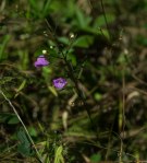
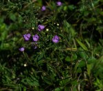
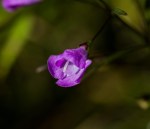
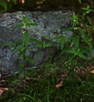
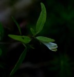
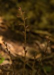
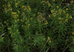
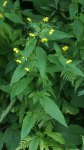
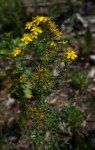
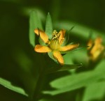
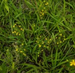
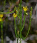
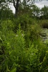
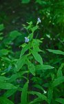
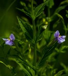
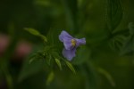
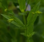
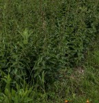
While monitoring the Burke Preserve late in August I found Agalinis tenuifolia — slender leaved false foxglove — for the first time in Deering. It was growing in a dry, exposed part of the Eversource right-of-way.
The plants stood out for their pink flowers on plants that stood no more than a foot high.
Agalinis tenuifolia plant
Agalinis tenuifolia plant
Agalinis tenuifolia flower
Agalinis tenuifolia is a native of North America and is widespread over eastern half of the USA and Canada. It is a member of the plant family Orobanchaceae, the broom-rape family. All members of this family, which includes nearly 150 genera and 3,311 species, are parasitic on other plants either entirely or, like A. tenuifolia, they have chlorophyll and can produce their own food at the same time that they parasitize nearby plants.
Two other members of the Orobanchaceae are common in Deering. Melampyrum lineare, cow wheat, is a small, inconspicuous herb that has small white flowers. This species has chlorophyll but is parasitic on roots of pine trees. Another common, and conspicuous member of the Orobanchaceae is beech drops, Epifagus virginia, which can be found in Deering’s forests where it parasitizes roots of beech trees. Agalinis tenuifolia is not specialized as to host.
Melampyrum lineare, cow wheat, plants with chlorophyll
Late summer here in Deering and fields and roadsides have been yellow for a while now. First came the black-eyed Susans, now goldenrods dominate. They’re the ones that form great swathes of yellow in sunny meadows and along roadsides.
Small digression . . .
Solidago, a name derived from Medieval Latin, Soldago (to make whole), was applied to this group of plants because of their medicinal value. There are lots of links for goldenrods and Solidago, on the WEB.
Goldenrods are a tricky proposition for anybody who wants to identify species. However, some species can be identified readily from a distance of 2 meters based on their form and/or flower color.
For example . . .
Solidago bicolor
The flowers of Solidago bicolor, which are just now (end of August) opening, are white with maybe just a touch of yellow. You might not think this one was a ‘goldenrod,’ but it is. This species is common here along roadsides and other dry sites in full sun.
Another distinctive goldenrod is no longer classified in the genus Solidago. Euthamnia graminifolia, which you will still find in wildflower guides under Solidago, really does not look like your average goldenrod. Its two common names reflect the differences. The very narrow, pointy leaves suggest leaves of grass, hence the species name graminifolia. The second distinctive characteristic of this species is the fact that the heads of flowers all form at more or less the same level (unlike other goldenrods where ‘flowers’ (really, heads of flowers or ‘racemes’) can look like fountains – – or star burst fireworks!). Thus the common name ‘flat-top-goldenrod.’
It’s an insect. A kind of a fly known as a ‘gall midge.’ Euthamnia graminifolia is the one and only host for the gall midge Asteromyia euthamniae. I have not found much information about this gall midge on line, but infected plants are pretty common here in Deering. Typically the larva of a gall midge burrows into the leaf’ and this elicits a response from the plant, which results in the formation of this characteristic gall. The gall is first bright yellow but becomes the tarry black shown in these pictures. After pupation an adult emerges to repeat the cycle. The Euthamnia gall midge, a nondescript fly, can repeat the cycle two or more times from spring through fall. Not all, but many grass-leaved goldenrod plants are affected and the species is common in Deering.
Euthamnia graminifolia leaves with tarry black galls
Euthamnia gall midge
Euthamnia gall midge
Euthamnina graminifolia is a native of North America, where it is widely distributed. The species typically occurs in damp places, but it can also be found under dry conditions along roadsides and in fields. This is one species that has been spread to Europe from North America. The species is commercially avilable.
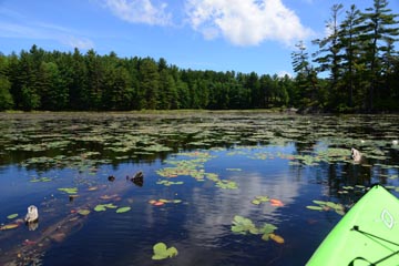
Smith Brook is one of my favorite water courses. It rises from Black Fox Pond, in Deering’s Audubon Wildlife Sanctuary, and flows for about a mile-and-a-half through conserved forest and wetland before entering a big wetland in North Deering. Water from that wetland feeds Dudley Brook and eventually the Piscataquog River.
Part of Smith Brook’s course is through forest. There the banks of the brook are sharply defined, the channel narrow. Trees line either bank and cool the waters. These places invite me on one summer’s day to sit down, back against a tree, and dream. In other places the brook’s channel is not so clear, a wetland; there is no forest here, just some scattered red maples and other shrubs growing among tussocks of grass and sedges. This time of year pickerel weed is in abundance and and in full bloom along the banks and in pools. These are sunny places, rich in life, but they do not invite me to get more than my feet wet. No protracted dreaming as I plot where to place my foot next.
Pickerel weed blooming in Smith Brook in the Garland Conservation Easement.
The Garland Conservation Easement – – named for Bob Garland, a longtime Deering resident who loved our forested town – – on North Road is in large part a wetland that is formed by Smith Brook. Two narrow arms of the easement form a ‘U,’in the middle of which sits a private residence. But, most of the easement is behind the house in the wetland. Much of the Garland easement abuts land that has been conserved by the Audubon Society and the Society for the Protection of New Hampshire Forests.
Garland Conservation Easement on North Road. Smith Brook forms an extensive wetland.
While monitoring the Garland easement early in August I found plants that I’d not seen before. The first was a shrub that I was sure was SOME sumac, not thinking that it was the dreaded POISON SUMAC until I got back home and pulled out of my sack the small branch that had berries and leaves. The rash and itching has largely subsided now, a few days later!
Another, far more interesting plant was BUTTON-BUSH, Cephalanthus occidentalis. Button-bush was recorded for Deering by a group of plant explorers in 1987, but I had not seen it until a few days ago. Button-bush is a shrub that grows in wet places and can reach several feet in height. It flowers late in the spring, the ‘flowers’ are white and are actually compound heads, each about an inch in diameter and comprising many tiny flowers. The pistils extend beyond the surface of the ball giving the appearance of pin cushions.
Button-bush with a monarch butterfly
The flowers of button-bush are fragrant and attract various pollinators, including humming birds and butterflies. The reddish-brown fruit persist through the winter and seeds are consumed by water-fowl.
Button-bush ‘flower’ with protruding pistils, each arising from a tiny flower.
Button-bush is native to eastern North America, but it is wide-spread throughout North America. Commercial cultivars are available for this attractive plant.
Almost August now and the wildflowers of early summer are giving way to late season blooms. Before the full onslaught of goldenrods, here is a selection of yellow flowers that you might see along our roads and in fields now.
Yellow-loosestrifes, Lysimachia species
The yellow-loosestrifes are members of the primrose family. They should not to be confused with – – and are not related to – – the invasive purple loosestrife. How do you distinguish them? it’s in the name: purple vs yellow. Lysimachia species make good garden plants. The common name, loosestrife, may have come from 16th Century English herbalist John Gerard, who wrote about a use of fringed yellow-loosestrife: fresh plants were tucked into the yokes of oxen, “appeasing the strife and unrulinesse which falleth out among oxen at the plough…”
Hummm . . .would it work today?
Lysimachia terrestris is an obligate wetland species, and is the most common yellow-loosestrife. You can find it growing in wet areas and in wet cuts along roadsides. Its common name is ‘swamp candles’ because the plants, which can reach 36′ tall, are unbranched and erect, and they terminate in a long raceme, or spike, of petty yellow flowers giving the appearance of a candle. At the base of each petal there are two red dots. Lysimachia terrestris is an obligate wetland species that is native to eastern North America. It’s flowering is on its last legs now, at the end of July.
Lysimschia terrestris
Lysimschia terrestris
Lysimschia terrestris
Two other yellow-loosestrife pecies that occur in Deering are L. ciliata (fringed yellow loosestrife) and L. quadrifolia (whorled yellow-loosestrife). They are not as common in Deering, anyway, as swamp candles.
Whorled yellow-loosestrife is native to Eastern North America and occurs in wet or dry disturbed habitats, grasslands and woodlands.
Fringed yellow-loosestrife was introduced to North America from Europe and today occurs throughout the continent. It can grow in wet or dry habitats.
Fringed yellow-loosestrife
Whorled yellow-loosestrife
Whorled yellow-loosestrife
St . John’s Worts, Hypericum species
St . John’s Worts (Hypericum species) are members of the family Clusiaceae, the mangosteen family. As is so often the case, this family is primarily tropical, where it is represented by trees and shrubs.
Common St John’s wort (Hypericum perforatum) is frequently found in Deering along roadsides as a tall, unbranched or infrequently branched plant (up to 2 ‘) with from 1 to several large, brilliantly yellow flowers forming near the tip. It’s fairly easy to identify from its stubby leaves and yellow flowers.
Common St John’s Wort is introduced into North America, where it is widespread, from Europe and Asia. It is considered to be invasive. St John’s Wort gets its name from the time of flowering, which coincides with the Summer Solstice (21 June) and Saint John-the Baptist’s birthday (24 June). The plant has been used medically since at at least the 1st AD century, when it was noted by the Greek herbalist Pedanios Dioskourides. Today Common St. John’s Wort is available in herbal shops in various forms and for various medical indications, which include antidepressant, anti-septic, anti-inflammatory,expectorant and tonic for the immune system, used for its alleviating properties. In recent times it has found its place in the treatment of depression and anxiety disorders. In numerous clinical double-blind trials against placebo and other antidepressants the whole extract of St.-John’s wort, e.g. as in Jarsin coated tablets, has proved to be just as effective as the other antidepressants for mild and moderate depression, but not for severe depression (Psychiatriki. 2010 Oct-Dec;21(4):332-8).
Common St. John’s Wort
Common St. John’s Wort
Hypericum perforatum is just one member of the family Hypericaceae that occurs in Deering, although it is the most conspicuous. Several species of Hypericum occur in wet areas, but they are smaller plants. I honestly cannot satisfactorily identify all of them. One diminutive species, Dwarf St. John’s Wort (Hypericum mutilum) is fairly common, including on some of the rocks in the Deering Reservoir.
One of my favorites, and one that is very easy to identify – – IF you see it – – is Hypericum gentianoides, or ‘orange grass.’ Orange grass occurs in bare, sandy places and is native to eastern North America, extending to the Mississippi River and beyond, into Texas. The plants do not reach more than 8″ in height. Plants are richly branched and erect; the stems are wiry, the leaves rudimentary, scaly. The flowers are about 1/4″ in diameter and brilliant yellow. The fruit is a red capsule that terminates each branch. Orange grass is an annual, but tends to come up in the same place as last year. It grows in several parts of Deering (it is blooming now, down in the grass at the triangle at Holton Crossing, and last year there was a quite a lot of it in the sand pit on Clement Hill Rd).
Dwarf St John’s Wort. The Ovaries and, eventually the fruit, sits above the petals.
Orange grass
Orange grass. Note the reddish capsules.
Orange grass. Note the wiry stems and scaly leaves.
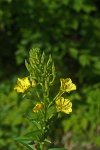
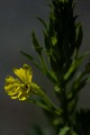
Evening Primrose, Oenothera biennis
Plants of the Common Evening Primrose, Oenothera biennisi), are common along dry roadsides. This plant is native to eastern North America but has become widely distributed.
Typically the plants are unbranched and can reach 7′ in height, although usually much shorter. Flowers occur over the upper quarter of the plant. Often flowers are solitary but several can arise simultaneously from a plant. The flowers measure 1″ – 2″ in diameter; they open widely in evening and are closed during the day. They are pollinated by moths at night, attracted by the lemony scent. The species name, biennis, implies that the plant requires two years to develop. In the first year a basal rosette, or ground-hugging radial cluster of leaves develops; in the second year the tall spike arises from the rosette and produces the flowers. Evening Primrose flowers from mid summer through into fall. The plant has a fleshy tap-root. A wide range of pharmacological activities have been attributed to Common Evening Primrose.
One of the most fun responsibilities of members of Deering’s Conservation Commission is the annual job of making sure that there have not been transgressions on any of the fifteen or conservation easements (out of a total of around 130 conserved lots, a bit over 7000 acres) located in town.
Annual ‘walking’ the easements, basically walking around the perimeter or – – at least — walking along those boundaries that are most likely to be impacted by people, takes conservation commission members into those conserved lots that most people never see. None of the conserved lots in town are very far from traveled roads, but – -as the saying goes – – 90% of the people never venture further than 20 yards from the road. The lots are mostly forested and few have marked trails. Once inside a 60 acre easement it is easy to forget that you are not in some isolated place despite the proximity of The World. Trying to determine the boundaries of an easement without using a GPS enabled device can be a challenge, although that is the way things were done until recently.
Titcomb easement outlined in red. My monitoring track in blue. Wetland crossing at the lower boundary.
The Titcomb easement is such a lot. The Titcomb easement, comprising 60 acres (average size of a conservation easement in Deering), was once the Harold Titcomb farm. In the 1920’s and 30’s the Titcomb Farm was noted as a commercial poultry farm, one of the few commercial operations in town. This easement is situated within the triangle formed by three Deering roads: on the west Deering Center Rd, on the north Clement Hill Rd, and on the east Dicky Hill rd.
North end of pond, the heart of the Titcomb Easement, in the fall of a normally wet year.
Traveling along those roads one would not imagine the beautiful wetland that lies just beyond the road and that makes up a large part of the easement. I got to experience the ‘wet’ part of the Titcomb wetland last week when I set out to walk the perimeter after heavy rain the previous day. Crashing through sensitive ferns is a wet job!. The southern boundary of the Titcomb Easement passes the edge of a large pond that is the heart of the wetland. For me and my monitoring it was at roughly the half way point. When I got to it I had to decide whether to avoid the wetland and pond by retracing my path, going way out of my way onto non conserved land to get around most of the wetland, or take advantage of this being a dry year and hope I could negotiate a thin beaver dam and step from grass tussock to tussock to get to the other side. That’s what I decided!
Crossing a beaver dam at the southern end of the big pond in the Titcomb Easement.Looking back at the wetland I’d crossed at the southern end of the Titcomb Easement.
With my walking stick probing the way forward I was able to get half way across, on the berm of a beaver dam when I started seeing pretty blue flowers on low growing herbs. This beaver dam was a rickety sort of thing where a wet foot or leg – – or more — was a distinct possibility. At one point, though, there was enough room to settle bit. Condense my stringy frame into a small sort of dry spot with the berm of the dam to my back and the open pond in front of me.
I love times like this. Especially so when the day is sunny, which this day was not. It’s quiet there and the feeling of being – – alone, the ‘first,’ remote – – is exhilarating. Dragon flies and water striders. Pond lilies and still water. Cat tails just now in flower and yellow swamp candles all about. I won’t say soporific (my foot was getting wet), but damned comforting to rest in that spot. I’ve felt this way when I worked in tropical rain forests. Romantic stuff. Hear the cycle of nature. To sit quietly in a forest, alone: itt beats any sermon I’ve ever heard.
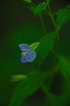
But, back to those pretty blue flowers that seemed to be growing all around me in the Titcomn Easement . . .
These were Allegheny Monkey Flower, Mimulus ringens. Its blue flowers kind of look like snap dragons but are the two are not related.
The Latin name of Allegheny Monkey Flower, Mimulus ringens, translates to buffoon (mimulus) that gapes (ringens). I guess this name was chosen because when the flowers are squeezed they look like monkey faces or at least they must have to the great botanist Carolus Linnaeus, who described the species in the middle of the 18th Century.
This native species grows in full sun in wetlands over most of North America. It is a perennial plant that can get to 3 ft tall and has a square stem. The flowers are pollinated by bumble bees, but if the invasive purple loosestrife is growing nearby – – the two occupy the same habitat – – Monkey Flower flowers might not get pollinated because the bumble bees choose the flowers of the invader. Native Americans and early settlers are said to have used the plant as greens.
Allegheny Monkey Flower is commercially available from several sources. It can make a lovely addition to your wetland garden.
Here are some pictures of Allegheny Monkey Flower.
Monkey flower along a beaver dam
Monkey flower
Monkey flower. Typically pale blue-violet, but can be pink or white. be
Monkey flower with 2-lipped corolla
Monkey flower with 2-lipped corolla
Monkey flower with square stem. Note that the leaves clasp the stem.
Lilies are now opening in our garden, the hiatus between the spring and summer bloomers over.
I know of two native lilies that occur in Deering. Mediola virginiana (Indian cucumber root, a member of the lily family) flowers in spring and, while its plants are conspicuous and its purple-berried fruits spectacular even, its flowers are quite hidden, although quite pretty.
Mediola virginiana plant
Medeola virginiana flowers
Medeola virginiana fruit
The second native lily that I’ve found in Deering is Canada lily, Lilium canadense. This is one of the most spectacular wildflowers found in Deering. The species was reported in the 1987 list but I had not seen it before this summer at the end of June along a small brook in West Deering near the McAlister fire station.
Canada lily is typically found in moist sites in woods, meadows, roadsides and so on. It is native to eastern USA and eastern Canada. The plant stands from 1 to 4 feet tall and bears from 1 – 5 blossoms. The flowers can be red or yellow; what I found in Deering has yellow flowers.
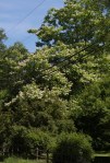
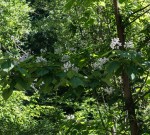
Coming up to Deering on Route 149 from Hillsborough, just past the cemetery at Clement Hill Road, on the left, you will see a very tall tree among other very tall trees that is just loaded with white flowers. A little further along on Deering Center Road, on the right, are a few smaller white-flowered trees. There is another really grand specimen of this same tree on Rt 9 heading into Concord at Currier Road. These are Northern Catalpa, Catalpa speciosa, and now is its time to bloom.
A large Northern Catalpa in flower
A young Northern Catalpa in flower
The exuberance of the blossoms of this tree, the mountain of white almost baroque flowers, seem out of place, here in flinty, cold, puritanical New England. But, here they are! And at least one of them has been in Deering for a very long time.
Flowering branch of a Northern Catalpa
Northern Catalpa. Note the. distinctive leaves
A flower of a Northern Catalpa. The yellow and purple stripes uiide bees to the nectar
Northern Catalpa is thought to be native to the mid-west, the Arkansas and Illinois region. The species was introduced into New England late in the 19th Century as a shade tree in big Victorian estates. There was never a big Victorian estate at the location of Deering’s big Northern Catalpa, at the intersection of Clement Hill Rd and Deering Center Rd. I think it is on land that was owned by an early Deering settler, L. Otis, and may be the lot owned much later by John and Mary Herrick. The Herricks took up residence in Deering in 1917 at a place described as ‘the house by the side of the road at Route 149 and Clement Hill Road, formerly owned by the Otises.’ The Herricks were crafts people who were renowned for their work in pewter, silver and semiprecious stones (including garnets, quarts, crystals, and amethyst found in nearby stone walls). They were said to guard a secret formula for preparing cattails for reed chair seats.
Northern Catalpa trees are fast growing and can attain 40 – 60 feet in height and an age of 50 – 150 years (thus it is at least possible that the Herricks planted this tree early in the 20th Century). In New England the tree only occurs in garden settings in full sun; it is not known to be a forest tree. It can withstand a wide variety of soil conditions. The fruit is a bean-like pod that can reach 15 inches in length; it splits open to discharge seed. Sometimes the tree is called ‘cigar tree’ because of the fruit.
The big Northern Catalpa at the intersection of Clement Hill and Deering Center Roads has a trunk circumference of 105 inches (the circumference of the Hillsborough County champion Northern Catalpa, in Lyndeborough, is 156 inches). Catalpa did not appear in the 1980 or 1985 lists of big trees found in Deering.
Northern Catalpa is unusual in that its flowers are pollinated by bees during the day and by moths at night. Bees are attracted by the yellow and purple ‘nectar guides’ in the flowers, and moths are attracted by increased nighttime nectar production.
Catalpa is a genus of the family Bignoniaceae. It is not related to Bigonia, which is a member of the family Bigoniaceae. Catalpa is the northernmost member of the family. The Bignoniaceae is largely a tropical family, where it is represented by gaudily flowering vines and trees. A second species of Catalpa occurs as an ornamental in New England. Southern Catalpa, C. bignonioides, is a smaller tree that has smaller leaves and the leaves, when crushed, are said to have an unpleasant odor. The Southern Catalpa also flowers later than its northern cousin. Although Southern Catalpa is not supposed to be found in New Hampshire, there a big, old Catalpa in the North Weare Cemetery, on Route 149, that is not yet flowering; its leaves have at least a ‘funky’ odor that some might find unpleasant. It is likely to be Southern Catalpa
Except for when the ground is covered with snow, partridgeberry (Michella repens) is a conspicuous element of the forest floor. Its little leaves, each about the size of a dime, remain green all year. Other species such as trailing arbutus and wintergreen occupy the same mesic or wet habitat, but leaves of partridgeberry are easily recognized by the white line that runs down the middle of each glossy leaf.
Partridgeberry flowers now, late in spring/early in summer. As I write this flowers are abundant in some forested sites in Deering. The plants form a carpet within which there are many little white flowers. The display is really very charming.
Flowers of partridgberry are paired, joined at the base and opening widely to 4 petals above a cylindrical corolla. The buds are pale pink but the open flowers are mostly white with only a little pink remaining in the corolla. The insides of the petals bear numerous very fine hairs. The flowers are pollinated by bumblebees. The bases of the flowers fuse. Nominally each flower produces 4 seeds, but because the ovaries are fused, each fruit is vaguely 2-lobed and contains 8 seeds. Pollen from different plants is required for fertilization
Partridgeberry is widespread throughout eastern USA and Canada as far west as the Mississippi River and even into Texas. It mostly occurs on dry-ish sites but can also be found in wet sites. The red berries are edible but really don’t have any flavor. Ruffed grouse, bobwhite quail, wild turkey, skunks, and white-footed mice consume partridge berries, but even with that partridgeberries can be found almost all year round.
Partridgeberry is distinctive throughout the year because of the evergreen leaves, each with a white line.
Partridgebrry bud fused at the base.
Note the cylindrical corolla and the fine hairs inside the petals.
The partridgeberry fruit has two lobes. Note that the leaves arise at right angles to each other.
The 300-odd-acre Tom Rush Forest in the center of Deering offers great opportunities for walking. There are eminently walkable Class VI roads in the forest and, for the more intrepid, lots of forest to bushwhack through.
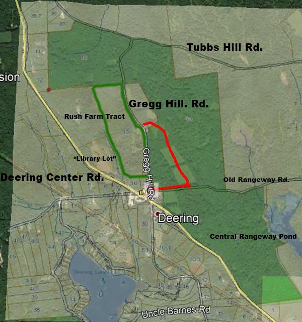
The Tom Rush Forest western half with Gregg Hill and Tubbs Hill roads and high hills. The track I followed along Gregg Hill and Tubbs Hill roads and through the forest is marked in purple
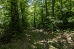
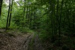
The three Class VI roads are Gregg Hill Rd, Old Rangeway Rd (not shown on the map) and Tubbs Hill Rd. The width of the forest is crossed by Gregg Hill Rd. Old Rangeway Rd. runs east from the Town Common, across the Tom Rush Forest, to a brook that feeds Central Rangeway Pond. Tubbs Hill Rd. forms the northern boundary of the Tom Rush Foreset. Tubbs Hill Rd is Class VI and is not town-maintained over most of its distance, including the forest boundary. It runs from Dickey Hill at the western end, to Driscoll Hill Rd., at the eastern end. Gregg Hill Rd. is about one mile in length. The first roughly quarter mile that runs uphill from Deering Center to the Lachance home is maintained year round. The rest of Gregg Hill Rd is a dirt track through the forest, ending in Tubbs Hill Rd. Old Rangeway Rd is closed by a locked gate at the western, town center end; it becomes Driscoll Hill Rd. at the eastern end. None of Old Rangeway Rd is maintained by the town.
All of these roads pass through forest and provide excellent opportunities for walking.
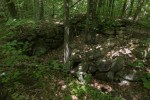
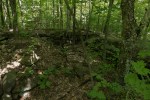
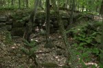
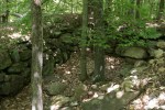
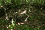
Cellar hole of 19th Century house of Dudley Chase. Note the massive colonial chimney base in the middle.House of Dudley Chase
Dudley Chase house. The full foundation is made entirely of granite, the stones so closely fitted that it is difficult to insert a hand in the cracks between them.
Central colonial chimney base in the Dudley K. Chase house
In the 18th and 19th Centuries several families lived along Gregg Hill Rd and Tubbs Hill Rd. There is a large cellar hole at the point where Gregg Hill meets Tubbs Hill Rd. This might be the remains of the home of Dudley K. Chase, whose name appears on a map from 1858. Tom Copadis (in the 1977 book Welcome home to Deering, New Hampshire) described this cellar hole, the blocks made entirely of granite, as a ‘marvel to behold.’ The house, which was was torn down in 1908, must have been elegant. The Chase family must have had a notable garden because the Chase garden at this point is noted in the deed for that lot. The map from 1858 shows that two Greggs lived on Gregg Hill Rd., ‘A.’ and ‘C.’ Gregg. These might have been sons of the original Alexander Gregg, Alexander and Christie. Gregg Sr. operated a sawmill near ‘Gregg’s Pond,’ known today as Deering Reservoir. Both Christie and Alexander served in town administration. Alexander was a member of the select board for several terms and was a state representative. Christie was town clerk for several terms. Alexander did not marry. Christie did marry and possibly had at least one son because a map from 1892 shows that a Mrs. W.A. Gregg lived in the same location as ‘C.’ Gregg.
Much of the western half of the Tom Rush Forest includes two of the highest hills in Deering with an about 80 foot drop separating them. The hill closest to Gregg Hill Rd, and very near the site of the C. Gregg house, is Gregg Hill. The elevation of Gregg Hill and its apparently unnamed sister hill is about 1320 ft, and the land falls sharply away to the east from these hills.
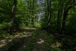
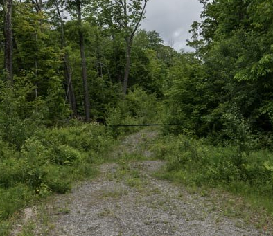
Gregg Hill road
Gregg Hiill road
Gregg Hill road
Tubs Hill Rd at Chase house
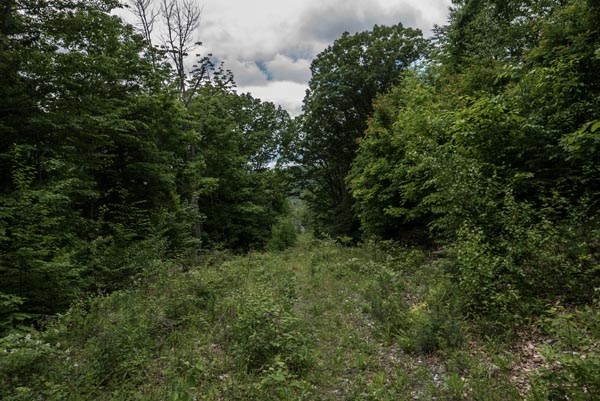
Tubbs Hill road
Tubbs Hill road with rock wall
Telecommunications facility at the high point on Tubbs Hill Rd
I walked along Gregg Hill Rd from just beyond the Lachance house to Tubbs Hill road, then westwardly along Tubbs Hill to a high point where there is a telecommunications facility. Just east of that high point the familiar three blotches of red paint on a tree indicate a corner of the Tom Rush Forest. On this walk I followed the boundary as best as I could (although this was not always easy). My objective was to walk over the highest hills while stopping at the overlook at the top of the ‘Library Lot.’
The track of my walk is shown in purple on the accompanying map. Although I tried to remain within the bounds of the Tom Rush Forest, you can see that I was not completely successful! The hills are completely forested, so there are no views. The forest itself is fairly open and is attractive. The dip between Gregg Hill and its sister might not look like much on the map, but on the ground the climb is steep.
High point adjacent to Gregg Hill. Ablut 1300 ft.
High point adjacent to Gregg Hill. Ablut 1300 ft.
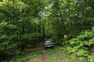
HOW TO GET THERE: Gregg Hill Road runs north from Deering Center past the Deering Community Church. There is private residence at the end of the town-maintained part of the road. The owner has requested that visitors not park in the bays there, or block the road. PLEASE RESPECT THE PRIVATE PROPERTY. You can park on the Class Vi part of Gregg Hill Rd just beyond the residence by pulling off the road. Please do not block Gregg Hill Rd at any point.
Parking on Class VI Gregg HIll Road beyond the private residence.
The walk up Gregg Hill Rd from parking is a bit steep but then the road is level or descends slightly to Tubbs Hill Rd. From the Chase house to the Tubbs Hill high point the way is very obvious, first gently descending and then more steeply climbing to the high point.
Here are some pictures from the walk. It is worth the half or three-quarters mile walk along Gregg Hill just to see the magnificent cellar hole of the Chase house.
The Tom Rush Forest, in central Deering, was formed in 2002 when the popular singer Tom Rush sold several lots to the Society for the Protection of New Hampshire Forests. Tom Rush Forest is the largest conservation easement in Deering, comprising 300 acres of forest and meadows. Abutting the Rush Forest the SPNHF holds the conservation easement on 40 forested acres that are privately owned and called the Rush Farm Tract. Abutting the Rush Farm Tract, on the Deering Center Road, is the ‘Gregg Hill Lot,’ also known as ‘the library lot.’ This town-owned lot is, in part, the steep meadow that can be seen from Deering Center Road, to the left of the Carew House and essentially opposite the town garage. There are many possibilities for recreation, walking and winter sports. in the Tom Rush Forest and land that surrounds it.
Early in the 19th Century several families lived around what is now the Tom Rush Forest, on Gregg Hill Road, Tubbs Hill Road, and Old Rangeway Road and today’s forest was all meadow – – known in part as ‘East Meadow,’ and ‘Berry field.’ Large meadows inside the Tom Rush Forest have been maintained along the east side of Gregg Hill Road, and those meadows feature in a walk (shown in red on the map) of about 1/2 mile from the Town Common, on Deering Center Rd, to the Lachance residence at the top Gregg Hill Road. We call that walk the Tom Rush Meadow Walk.
Gate across Old Rangeway Rd at Gregg Hill Road, near the Town Common
Beginning at the gate across Old Rangeway Road, near the Town Common and the Deering, follow Old Rangeway Road uphill for a little less than 1/4 mile. From the top of the hill the trail leads left and immediately enters the first meadow. The way through the meadows is mown irregularly to make a more or less clear path for about 1/4 mile to return to Gregg Hill Rd. The last third of the walk passes through open forest.
The slope from the gate at Gregg Hill Road to the top of the hill is moderately steep and follows along a rutted dirt road. From the top of the hill the path through the meadows back to Gregg Hill Road is level easily traversed – – even with a perambulator. There are no vistas from the meadows.
Lookiing down Old Rangeway Road toward Deering CenterMown path through a meadow in the Tom Rush ForestPath through open forest.Entrance to the Tom Rush Meadow path from a private residence at the top of Gregg Hill Road.
The meadows harbor a nice diversity of flowers. When I walked it in early June a stunningly blue introduced Veronica, V. austriaca saw-leaved speed-well, was in bloom. There were a lot of blackberries and dewberry, a close relative of blackberry that scrambles along the ground. Dewberry fruits before blackberry. Its fruit look like fruit of blackberry and can be just as sweet. The dewberry plant is thorny/hairy, so the biggest challenge might to be in collecting the fruit without getting scratched. There were also pale violet fleabanes forming large colonies in the grass. Milkweed plants were conspicuous and I saw a monarch butterfly, which feeds exclusively on milkweed. I was very happy to see a lot of ash seedlings but not so happy to see a large colony of the invasive black swallow-wort (Cynanchium louisiae). I am sure there will be a succession of flowers through the season. At the edge of one of the meadows there is an impressive wonderfully branched red oak tree.
Black swallow-wort, an invasive plant that crowds out other vegetation.
blackberries with Veronica austriaca
Dewberries scrambling over the ground.
Fleabane with pale violet flowers.
Orange hawkweed, HIeracium aurantiacum, in the middle of the path.
Veronica austriaca, an introduced speed-well
An old, much branched oak at the edge of a meadow in the Tom Rush Forest
Parking on Class VI Gregg HIll Road beyond the private residence
It is possible to park at the top of Gregg Hill Road but please remember that there is a private residence there. The owner has requested that people not park in the bays. Gregg Hill Road is a Class VI road and there is room to park on the side of the road beyond the residence. Please do not block Gregg Hill Road.
The Tom Rush Meadow Walk would make for a good trail for families. It is short, only 1/2 mile each direction, and you could post a car at each end. The trail is easy to follow; it is open and there is a diversity of things to see. With some effort you could push a perambulator along. It would be fun for winter’s snowshoeing or cross country skiing at least at the level top through the meadows.