The 300-odd-acre Tom Rush Forest in the center of Deering offers great opportunities for walking. There are eminently walkable Class VI roads in the forest and, for the more intrepid, lots of forest to bushwhack through.

The three Class VI roads are Gregg Hill Rd, Old Rangeway Rd (not shown on the map) and Tubbs Hill Rd. The width of the forest is crossed by Gregg Hill Rd. Old Rangeway Rd. runs east from the Town Common, across the Tom Rush Forest, to a brook that feeds Central Rangeway Pond. Tubbs Hill Rd. forms the northern boundary of the Tom Rush Foreset. Tubbs Hill Rd is Class VI and is not town-maintained over most of its distance, including the forest boundary. It runs from Dickey Hill at the western end, to Driscoll Hill Rd., at the eastern end. Gregg Hill Rd. is about one mile in length. The first roughly quarter mile that runs uphill from Deering Center to the Lachance home is maintained year round. The rest of Gregg Hill Rd is a dirt track through the forest, ending in Tubbs Hill Rd. Old Rangeway Rd is closed by a locked gate at the western, town center end; it becomes Driscoll Hill Rd. at the eastern end. None of Old Rangeway Rd is maintained by the town.
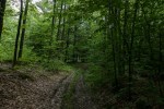
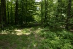
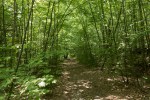
All of these roads pass through forest and provide excellent opportunities for walking.
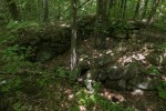
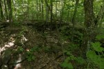
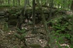
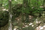
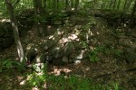
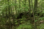
In the 18th and 19th Centuries several families lived along Gregg Hill Rd and Tubbs Hill Rd. There is a large cellar hole at the point where Gregg Hill meets Tubbs Hill Rd. This might be the remains of the home of Dudley K. Chase, whose name appears on a map from 1858. Tom Copadis (in the 1977 book Welcome home to Deering, New Hampshire) described this cellar hole, the blocks made entirely of granite, as a ‘marvel to behold.’ The house, which was was torn down in 1908, must have been elegant. The Chase family must have had a notable garden because the Chase garden at this point is noted in the deed for that lot. The map from 1858 shows that two Greggs lived on Gregg Hill Rd., ‘A.’ and ‘C.’ Gregg. These might have been sons of the original Alexander Gregg, Alexander and Christie. Gregg Sr. operated a sawmill near ‘Gregg’s Pond,’ known today as Deering Reservoir. Both Christie and Alexander served in town administration. Alexander was a member of the select board for several terms and was a state representative. Christie was town clerk for several terms. Alexander did not marry. Christie did marry and possibly had at least one son because a map from 1892 shows that a Mrs. W.A. Gregg lived in the same location as ‘C.’ Gregg.
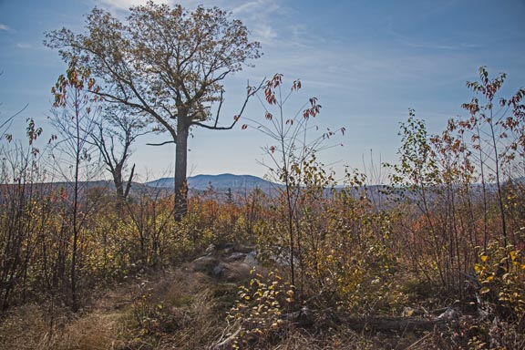
Much of the western half of the Tom Rush Forest includes two of the highest hills in Deering with an about 80 foot drop separating them. The hill closest to Gregg Hill Rd, and very near the site of the C. Gregg house, is Gregg Hill. The elevation of Gregg Hill and its apparently unnamed sister hill is about 1320 ft, and the land falls sharply away to the east from these hills.

I walked along Gregg Hill Rd from just beyond the Lachance house to Tubbs Hill road, then westwardly along Tubbs Hill to a high point where there is a telecommunications facility. Just east of that high point the familiar three blotches of red paint on a tree indicate a corner of the Tom Rush Forest. On this walk I followed the boundary as best as I could (although this was not always easy). My objective was to walk over the highest hills while stopping at the overlook at the top of the ‘Library Lot.’
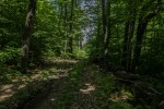
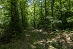
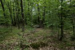
The track of my walk is shown in purple on the accompanying map. Although I tried to remain within the bounds of the Tom Rush Forest, you can see that I was not completely successful! The hills are completely forested, so there are no views. The forest itself is fairly open and is attractive. The dip between Gregg Hill and its sister might not look like much on the map, but on the ground the climb is steep.

HOW TO GET THERE: Gregg Hill Road runs north from Deering Center past the Deering Community Church. There is private residence at the end of the town-maintained part of the road. The owner has requested that visitors not park in the bays there, or block the road. PLEASE RESPECT THE PRIVATE PROPERTY. You can park on the Class Vi part of Gregg Hill Rd just beyond the residence by pulling off the road. Please do not block Gregg Hill Rd at any point.
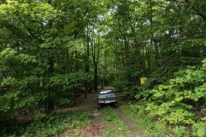
The walk up Gregg Hill Rd from parking is a bit steep but then the road is level or descends slightly to Tubbs Hill Rd. From the Chase house to the Tubbs Hill high point the way is very obvious, first gently descending and then more steeply climbing to the high point.
Here are some pictures from the walk. It is worth the half or three-quarters mile walk along Gregg Hill just to see the magnificent cellar hole of the Chase house.
