Welcome to Deering

TWO MUSHROOMS: CANTHARELLULA UMBONATA AND MICROPHALE PERFORANS

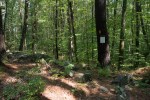
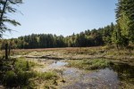
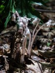
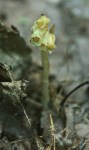
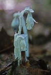
Rain in the late summer and early fall can bring out a dazzling array of mushrooms in our northeastern forests.  All sizes, shapes and colors of mushrooms scatter about on the forest floor without obvious design. But there actually is a plan. Many mushrooms form more or less specific associations with roots of certain kinds of trees, either hardwoods or conifers and are essential for the health of those trees. Other mushrooms grow on decaying logs or on leaf litter without any obvious specificity as to their substrate.  Along with bacteria, insects and a host of microbes the fungi recycle rotting wood and fallen leaves and contribute to nutrient recycling of the forest. These recycling fungi are called ‘saprobes’ which means that they live on dead plant material. One would not think of saprobes as requiring specific substrates, but two apparently saprobic mushrooms that we see in the litter of our forests actually are specific as to what they grow on.


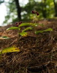
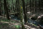
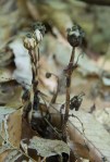
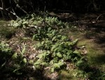
Cantharellula umbonata, also known as the grayling, grows among hair cap mosses (Polytchum species) and is native to eastern North America. The mushroom clearly rises from the mass of mosses but does not appear to cause them any harm. It is not a big mushroom. Its cap is only an inch or so in diameter and its stalk is up to 4” long and slender. The cap is gray (hence ‘grayling’) and the gills below the cap are off white, but the cap and gills stain red when bruised. Because the gills under the cap tend to run down the stalk, similar to what is seen in the chanterelle mushroom, the grayling was once classified as a chanterelle. Unlike chanterelles, the gills of the grayling are sharp-edged, not rounded as in the chanterelle. I have not seen research into why the grayling grows only on or with the moss. The moss appears unaffected, so it is not a question of parasitism. Is there any exchange between the mushroom and the moss? An interesting subject for research! I found the grayling that we see here on the trail to High Five.

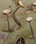
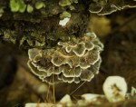
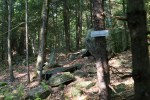
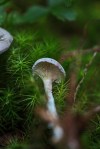
The second ‘host’ specific saprobic mushroom that is common in hemlock and pine forest in and around Deering is Micromphale perforans. This mushroom is very small, the cap no more than ¼” in diameter and is perched atop a very fine, black stalk that is no more than 1” long. This fungus is so small that it does not have a common name. We see it frequently here hemlock and pine forests, where you see it on the ground as tiny white spots. If you carefully pick up one of those little mushrooms and pull apart the debris you will see that the Micromphale is growing out from old hemlock, leaves or infrequently pine needles. Actually, fungi live in the roots, leaves and trunks of trees and leaves of most plants without causing any ill effects. These fungi, called endophytes, can be beneficial to the plant in several ways. It is a case of mutualism where both the fungus and the plant benefit. We do not know whether the Micromphale is an endophyte. How does it get there? Is the fungus waiting in the ground for the leaves to fall before invading them, or is it present in the leaves, only producing the little mushroom and completing its life cycle once the leaves have fallen?

The life styles of both of these mushrooms are curious and little known. Both interesting subjects for research! We know so very little about how our planet functions. It is these little interactions that, taken together, are critical for ecosystem functioning. So, yes, it is worth knowing the answers to these questions!

Margaret Wood Memorial/Pinnacle Trail


The Margaret Wood Memorial is a 20 acre conservation easement in East Deering, at the top of Peter Wood Hill Rd.  The land is privately owned but the conservation easement on the Margaret Wood Memorial has been held by the Society for the Protection of New Hampshire Forests since 1970.

Margaret Wood was the wife of Peter Wood. In 1917 the Woods purchased a large farm on what is now Peter  Wood Hill where they raised cattle and grew potatoes. Part of this farm is now the Margaret Wood Memorial.

Margaret Wood was a founding member of the Deering Community Club. The members of Deering Community Club were originally all women. Among other good deeds, the women of the Club were responsible for arranging running water in Deering Town Hall in the mid 1920’s. Many men in town contributed their labor to this project. The men impressed the ladies of the Deering Community Club so much that in 1927 men were admitted to membership in the club.  Soon thereafter town hall was extended to what we know today.

Margaret and Peter Wood were grandparents of several generations of current and former Deering Residents including Tom Coppadis, the owner of  the land on which the Margaret Wood Memorial is found.

How to get there: Please contact me if you would like to download the Pinnacle Trail map. From the Hillsborough end of Deering Center Rd. (NH Rt 149) turn on to Clement Hill Rd. Follow Clement Hill until it turns sharply right (about 1.5 mi). North Rd continues straight at this point. Follow North Rd to a T at Pond Rd (about 1 1/4 mi). North Rd continues to the right. Follow North Rd, turning sharply left at Clement Hill Rd to become Peter Wood Hill (approx. 1 1/4 mi). Continue a short distance to a small parking area on the left (approx. 300 yds). The trail head is about 20 yds downhill from the parking, on the left.   From points to the east pass through Weare on NH rt. 149 to Cross Rd., at the Wilds. Follow Cross Rd to a T at E. Deering Rd. (about 3/4 mi). Turn Right on East Deering Rd. and follow, turning sharply left at Gove Rd. (about 3/4 mi) and following to a T (approx. 1 mi) at Peter Wood Hill Rd. Turn left on Peter Wood Hill Rd and continue approx. 0.6 mi, passing Glen Rd. on the left and where the road becomes dirt, to the parking area on the right at the crest of the hill.

The Pinnacle trail is a loop that begins and ends on Peter Wood Hill. The lower end is opposite the point where Glen Rd meets Peter Wood Hill and the upper part is about 500 ft further uphill. There is a pull off large enough for 1 or 2 vehicles at the upper end, where Peter Wood Hill turns left. The entrance to the trail is slightly downhill on Peter Wood Hill from that point and is marked by a sign.

What’s the trail like?  The Pinnacle Trail loop is about 1 mile in length. The trail is reasonably well marked with white blazes on trees (but the blazes could use renewal as I write this in 2017). The trail has been well trodden over the years and is easy to follow. The trail is even underfoot, so walking is easy. For the most part the trail is level with little gain or loss in elevation however at the Glen Rd end there is a slightly steepish slope over maybe 50 yards. An option to returning to parking from Glen Rd is simply to walk through the woods, parallel to the road. Near the midpoint and the picnic table there is a side trail to ledge with an overlook however I did not see blazes on this overlook trail. Nonetheless, it would not be possible to miss the overlook or to become lost as the loop is very short and the edge of the ledge with overlook obvious. A log bench has been placed at a view-worthy spot near the picnic area, and vegetation has been kept at bay to allow for the view.

What’s the payoff? The forest in the Margaret Wood Memorial is a mixture of pine, oak and maple. The forest is very open, with little undergrowth. This makes the Pinnacle Trail a pleasant ramble through non-threatening woods. The two views are to the north and northeast, and this includes a good view of Dudley Brook and the hills beyond Henniker. There is a rustic picnic table at the highest point in the Memorial providing a great place for picnicking while taking in the views. The open forest gives lots of room for kids to run around. In early days Peter Wood Hill was known for winter sports. Today the Pinnacle Trail is a good place for snowshoeing or cross country skiing.


Smith Brook Trail

Please contact me if you would like a downloadable map of Smith Brook Trail to.

To Get There. The Audubon Preserve is located in Deering on Clement Hill Rd. From Deering Center Rd (NH Rt. 149) follow Clement Hill Rd., turning sharply right where North Rd goes straight (approx. 1.5 mi) and past the first marked parking area, on the right, then downhill past two private homes and down a steep dirt road to the bottom of the hill (approx. 09 mi), opposite Tree Frog Pond on the left. There is  parking area on the right.  You can reach Black Fox Pond from this parking area.

Smith Brook drains Black Fox Pond to the Piscatquog River through Dudley Brook. Pick up Smith Brook Trail directly opposite the parking area, across Clement Hill Rd. The trail is marked with yellow blazes and the entire loop is  a little over 1 mile. The trail passes through a mixture of forest types, pine at first and the mixed hardwood. The trail is level, with no gain or loss in elevation, and smooth with the exception of one short stretch that crosses the drainage of a small pond. It is an easy trail.

The first part of Smith Brook Trail, the western edge, follows Tree Frog Pond. This is a nesting site for wood ducks and wood duck nesting boxes have been placed on the pond. Great blue heron also nest on the pond. Both of these species are sensitive to noise, so if you want to see them you should go quietly.  On June nights you will hear the tree frogs singing. Some interesting plants along the trail are the orchids slender ladies’ tresses (Spiranthes lacera) and checkered rattlesnake plantain (Goodyeara pubescens),  and pipsissewa (Chimaphila umbellata) and a Pyrola species for which I have not yet seen flowers. The Spiranthes and Pyrola should flower in July or August. In September 2017 I found a beautiful, but deadly destroying angel mushroom (Amanita virosa) at the bridge across Smith Brook.

The trail follows along Smith Brook to a bridge and then follows the brook back past a beaver marsh, returning to Clement Hill  Rd at Smith Brook, where you turn right along the road for about ¼ mile to return to the parking area.

ABOUT BIG TREES IN DEERING

Residents of Deering have always valued the rural character of their town. They have consistently supported conserving forested land and active farms over commercial development in order to maintain that rural character of the place. They spent a lot of time outside in nature, whether as hunters or just enjoying their natural environment

In 1980 a group of Deering residents set out to locate the largest native and nonnative trees in town. This list was updated in 1985. You can see and download the Big Tree list here.

In 2016 members of the Deering Association began a project of once again updating the list of big trees by locating and documenting those on the old list and adding new records and species.  Finding a particular trees that was included on a list  thirty-five years ago is a difficult task. At that time it was not possible to add map coordinates to tree locations; there was no smart phones or GPS devices! Locations were given by property owner so even then it is difficult to locate a specific tree in a given parcel. Moreover, many of those properties have passed hands and there is no easily accessible way to find out where a specific parcel is today. Sadly, many of those who reported trees thirty-five years ago have passed away or just do not remember.A small part of our History gone.

In this Big Tree category we present the results of trying to find Deering’s biggest trees.  We certainly encourage Deering residents who might know of the location of a particular large tree, or even a tree that is on the list, to contact us.

You can find all the big trees in New Hampshire at the UNH Cooperative Extension Big Tree site.

Engagement of our Community in this project, just as the Community was engaged all those years ago, will be very helpful as we attempt to account for Deering’s largest trees!

ABOUT HIKING TRAILS IN DEERING

You can download a map of hiking trails in Deering here.

About 1/3 of Deering’s land, 7155 acres, is in conservation easement and thus is protected forever. Most of the hiking trails are Class 6 roads, roads that are seasonally passable but that are not maintained by the town. These are great places for leisurely walking in nature. Often there will be rock walls alongside the roads, or wetlands. Examples are Hedgehog Mt. Rd, Falls Rd and Lead Mine Rd.

There are a few marked trails through forests. These include the Hedgehog Mt. Ridge trail, from Hedgehog Mt. Rd through to High Five, about 5 miles. This is the longest marked trail in town. Other marked trails are much shorter. They are found in the Deering Audubon Sanctuary on Clement Hill Rd, the Pinnacles on Peter Wood Rd at North Rd., Wilkins-Campbell Forest from Wolf Hill Rd to the Deering Reservoir, the Burke Family Wildlife Preserve on Pleasant Pond Rd near Rt. 149, and a very short trail at the Deering Preserve at Falls Rd, off Old County Rd. The walk from Sky Farm Rd to High Five is along a dirt road and is about 1/3 mile in length. Some people go to High Five for star gazing or viewing the full moon.

With the exception of the Hedgehog Ridge trails, the other marked trails are rather short but are level and ,more or less smooth and fairly easy to walk on.

I have added links to XML files that should enable you to download hiking trails to your Garmin device.

Remember that dogs should be kept on leashes, there should be no fires or camping in Deering’s conserved lands.


TWO MYCOHETEROTROPHIC WILDFLOWERS

You probably know that plants are green because of chlorophyll in their leaves. It’s the chlorophyll that enables plants to convert carbon dioxide into food using the light of the sun.  A conceptually wonderful, simple plan that keeps our crops growing and evergreens ever green. It all works pretty well until one foolish species – Homo sapiens aka you and me – starts dumping more carbon dioxide into the atmosphere than the plants on Earth, including all those little ones in the ocean, can cope with. Then there is overload and the unabsorbed carbon dioxide forms a sheath around the planet, and that really messes with the climate.

But, that’s another story….

Green plants are autotrophs, which means that they produce their own food.

Some plants are not green. They’re called heterotrophs. They are bona fide plants, it’s just that they cannot produce their own food because they lack chlorophyll. So, how do they cope with this whole nutrient gathering thing?

Epifagus virginiana, beech drops or boom-rape parasitizes beech roots

Some of them parasitize the roots green plants. A common example in Deering is beech-drops, Epifagus virginiana¸ which parasitizes roots of beech trees.  The Epifagus draws its nutrients directly from the roots of the beech.  There are other less conspicuous examples of such plants in Deering.


Other heterotrophs get their nourishment indirectly from green plants through the intermediary of a fungus. These plants are mycoheterotrophs (myco = fungus). Monotropa uniflora, known as Indian pipe or ghost flower and Hypopitys monotropa, pinesap, are two mycoheterotrophs found in Deering. They parasitize mushrooms that have beneficial connections to trees. Appearances notwithstanding, both Monotropa and Hypopitys are related to blueberries.

Some plants, such as orchids, produce chlorophyll — so they can photosynthesize — but they also depend at least in part on being associated somehow, as parasites or some sort of mutualistic relationship, with mushrooms and mushroom relatives.  But, that is also another story.

Both Indian pipe and pinesap grow in dark, rich forests. Indian pipe is  far more common in Deering than pinesap. Both are parasitic on mushrooms but to appreciate this, you have to understand a little of mushroom biology.

Mushroom biology 101. The mushroom you see is only one part of the body of the mushroom. The mushroom you see is the result of sexual reproduction and is thus the part of the mushroom that holds the spores (which are roughly equivalent to seeds, but only roughly). You will never see most of the ‘mushroom’ because the real body of a mushroom consists of fine filaments that grow through the earth or decaying wood and other plant material.  This part of the mushroom, the fine filaments, is called the mycelium. The mycelium of many mushrooms form associations with the roots of trees. These associations are called mycorrhizae (myco = fungus and rhiza = root). The mycorrhizae are essential for tree growth because the fungus, as it scavenges in the litter, brings carbon nourishment to the tree. The tree sends beneficial goodies back to the fungus. So, it’s a mutually beneficial relationship for the two partners. Mycoheterotrophs, the Monotropa and Hypopitys, are interlopers that take and give nothing in return!

Monotropa uniflora is known as Indian pipe because initially the single white flower sits atop a white stalk opens downwardly, thus giving the plant the appearance of being a pipe. This plant is also are known as ghost flowers – or even corpse flowers – because of their translucent white color. One could well imagine the white stalks springing from some unspeakably horrible ‘thing’ in the earth.

Flowering of Indian pipe begins in spring and continues into the autumn. As the season progresses, the single nodding flower gradually turns upright. Pollination is effected by bees. Gradually the leaves turn black and eventually the whole plant becomes brown and dry. The old plants are common. Seeds produced in the capsule are wind dispersed when the capsule cracks.

The genus Monotropa differs from Hypopitys most conspicuously in the number of flowers produced by each plant, one in Monotropa and several in Hypopitys.

These mycoheterotrophs and partial mycoheterotrophic plants such as orchids, pinesap and Indian pipe, all produce very very small seeds, called ‘dust’ seeds. They are so small that, unlike larger seeds, have no or very little to provide the germling. After they are dispersed the seeds may lie in the environment for several years. During that time they may germinate, but germination rates are very low for these tiny seeds. While those that do germinate are developing they require a relationship with fungi to bring the germlings carbon nourishment. At first many fungi that live in the soil may be involved in this process, but over time there is more or less specialization with particular fungi. Thus Monotropa parasitizes members of the mushroom Russulaceae (Russula and Lactarius) while Hypopitys parasitizes members of the mushroom family Tricholomataceae. These mushrooms are all common fungi in Deering’s forests.

There is so much in the environment that we do not see. Amazing how life proceeds without our direct involvement. These processes are essential to cycling life. When we disturb some aspect of the environment, even a little, inconspicuous bit of it, we are messing with the cycle of life. The outcome is rarely good.

DEERING WILDLIFE SANCTUARY

DEERING WILDLIFE SANCTUARY

Directions

Take Routes 9 and 202 to Hillsboro Center/Route 149 exit and drive into Hillsboro. At the light in the center of town, turn south on to Route 149. Drive one mile; then turn left onto Clement Hill Road. After approximately 1.5 mile; Clement Hill Road makes a right turn. The year round parking area is 0.4 mile on the right. Further down Clement Hill Rd, at the bottom of a steepish hill, there is another parking area. Please note that winter and spring road conditions can make travel difficult on the last section of Clement Hill Road a challenge.

The Audubon Society of New Hampshire has preserved nearly 700 acres of land in this part of Deering. You can read about the history of these lands by following this link http://www.nhaudubon.org/deering-wildlife-sanctuary/.

Three trail loops constitute the Sanctuary’s trail system. Each trail is combined with portions of Clement Hill Road to form the loops. Clement Hill Road has summer maintenance only beyond the Smith Farm and is closed to vehicles from October through April. Dogs on a leash are allowed on the Patten Farm Trail only. You can download a trail map and a trail guide  by following these links.

Black Fox pond is my favorite kayaking pond in Deering. Few visit the pond, giving a sense of solitude when on the water. Vegetation grows to the edge of the pond, and on the islands in the pond, enabling the kayaker to get close to flowers. There is a great profusion of flowers on Black Fox pond. These include the insecticolous plants floating bladderwort (Utricularia radiata, flowering July and August) and sundew (Drosera intermedia, flowering mid to late July), gaudy sheep laurel (Kalmia angustifolia, flowering in June) and the orchid Pogonia ophioglossoides (flowering late June, early July). There are also early spring bloomers high bush blueberry, Andromeda and male berry. Near the lower parking area there is a good population of corn lily (Clintonia borealis). Early in spring this plant bears small yellow flowers; the fruit, a deep blue berry, forms over the summer.

For kayaking park at the lower area, opposite Tree Frog Pond. It’s about 150 yards along a level trail from the parking area to the pond. Put in a short distance along the trail to the right when you reach the pond. The trail from the parking area is smooth, covered with pine needles and other leaf litter, thus making dragging a kayak a simple job.

The trail from the upper parking area is on a gentle slope; it’s level and is easy to follow. In spring you can find trillium and, later, lady’s slipper orchids. When the trail reaches the pond the vegetation changes, possibly in response to the low pH of the pond’s water. Blueberries, both high bush and low bush are thickly disposed along the sides of the trail. In June you will see a lot of Lady’s slippers here and, toward the dam, there are trailing arbutus, bunchberry and partridge berry. Unless you want to walk back up, either retracing the trail or continuing out to  Clement Hill Rd, you might consider spotting cars at each end of the trail.

I have snowshoed on the pond in January when checking the several wood duck boxes that are located there. It was a cold and windy day, the snow was deep and crusty, and I was inexperienced with snow shoes. An experience I will not soon forget. But … give it a try!

BLADDERWORTS – KILLERS ON THE POND!

BLADDERWORTS: KILLERS ON THE POND!

Water lilies are so romantic, aren’t they? The objects of paintings and poems. But, out among them on dreamy p

onds there lurks a seamy side of the pond: bladderworts. Dressed in deceptively pretty yellow flowers these plants spell trouble – for water fleas.

Bladderworts, Utricularia species, typically grow in open, acidic water where nutrients and CO2, an essential ingredient for photosynthesis, are in low concentrations.  To supplement the low nutrients, the plants eat tiny aquatic animals: they’re carnivores.  Bladderworts are the most diverse of the carnivorous plants, and twelve of the about 200 species world-wide are found in New England.

Our bladderworts typically have stalked, yellow, snapdragon-like flowers that are about the size of a quarter.  The plants lack roots and are free-floating. One common species here, U., radiata, is distinctive for the radiating arms that sit on the surface of the water, keeping the plant upright. Bladderwort’s long branches extend downward into the water.  Leaves form from the immersed stems and are finely dissected and fan-like, increasing their surface area and thus, enhancing the ability to absorb available nutrients.

Bladderworts take their name from the tiny dark – black or dark green — bladders, or utricles, that form from the leaves.  Take a bladderwort plant from the water you will see the little bladders looking like tiny grains in the long mass of stems and leaves. The bladders are highly specialized traps. Fine hairs at the opening of the bladders sense passing animals such as water fleas and, when triggered, cause the bladder to suddenly inflate, creating a vacuum and sucking the hapless animals in, closing the door behind them — and all in less than a hundredth of a second. Digestive enzymes similar to papain, which helps break down meat fibers, make it a meal.

Bladderworts flower throughout most of the summer and die back in the fall. Lacking roots, they cannot be expected to survive the winter like other plants, but they develop dense masses, called turions, that include nearly fully formed leaves. These structures sink into muck at the bottom of the pond, and in spring the warming water causes the stem inside the turions to elongate and form a new plant.

Turions are heavy and not easily dispersed. Bladderworts can be dispersed by fragmentation, and U. inflata, native to southeastern states, has become invasive in Rhode Island, thought to have been introduced by humans. The plants do produce seeds. Bee pollinators are attracted by the yellow color of the flowers and nectar that is contained in a spur that projects forward from the flower. The flower is constructed so that bees can enter for the nectar and pollen but they cannot self-fertilize the flower.

A recent scientific study reported that the genome of one bladderwort has the smallest reliably sequenced plant genome. Despite the small size of the genome, it has more genes than well-known plants such as grape that has a much larger genome. Over the 10 to 20 million years that U. gibba has been around there has been considerable gene duplication and deletion. The genes that make up the genome have been pared down to essentially two sorts: those that define U. gibba as a plant, like genes for building cell walls, responding to light and producing flowers, and those that are essential for carnivory.

It is thought that carnivory was originally a defense mechanism to prevent predation by fungi and animals, much like caffeine protects coffee from herbivores. Bladderworts went a step further from prevention to predation. Evolution made of them stripped down killers, creating mayhem among our romantic waterlilies. Water fleas beware!

A version of this post appeared in the summer newsletter of the Piscataquog Land Conservancy


HIGH FIVE/WILSON HILL

Please contact me if you would like to download a map of the High Five Trail.

The High Five trail is rather short. We made the return hike in about an hour, allowing some time at the summit to take in the view but otherwise steady walking.

Wilson Hill, also known as High Five, is the southernmost high point of a ridge that extends over Hogden Pasture, Hedgehog Mt to Little Hedgehog Mt in the north. This long ridge separates West Deering from the rest of the town and there is no direct route from central Deering to West Deering. The ridge also forms the western boundary of a long wetland that drains to the north into the Contoocook River by Manselville Brook and to the south into the Reservoir and from there into the north branch of the Piscataquog River. The eastern bound of this wetland is dominated by Clark Summit.

Wilson Hill, at 1400 ft,  is the second highest point in Deering, behind Clark Summit. But, the panoramic views of Mt Monadnock in the southwest to Mt Lovewell in the north are delightfully accessible by a fairly easy walk of about 1/3 mile from  Sky Farm Rd, or a somewhat more strenuous ramble from Falls Rd. Wilson Hill is really an open pasture with a few trees. Apart from  the ticks, that are found everywhere here, it provides an excellent setting for a picnic (remember though, NO FIRES). The summit is an excellent place for star gazing!

There is limited space for parking at both ends of the High Five trail, but especially so at the Falls Rd. end. Sky Farm road is wide and relatively little traveled, thus offering reasonable space for on-road parking.

Sky Farm Rd is located at the southern end of Old County, opposite the point where Reservoir Rd meets Old County Rd. The entrance to the ‘High Five Reservation’ is about 3/4 mi from Old County/Reservoir Rds on Sky Farm Rd. It is marked by a Society for the Protection of New Hampshire Forests sign; the wide trail is blocked by a metal gate. Access to Wilson Hill is over a gently sloping dirt road which first passes through forest and then breaks into the open at the summit.

A maple tree at the summit indicates the opening for the Hedgehog Ridge Trail, which leads from Wilson Hill down to Falls Rd and then back up onto Hedgehog Ridge and, ultimately, Hedgehog Mt. Rd in the north. The trail to Falls Rd from the summit is well marked with yellow blazes and thus is easily followed.  The climb down from the summit is a little sharp over 100 yards or so, but once it enters the forest the slope becomes gradual until reaching a brook. After a short climb from the brook, the trail is level to Falls Rd. The Hedgehog Ridge trail continues immediately across Falls Rd.

The return hike from Falls Rd to Wilson Hill is an easy, not too strenuous afternoon’s walk. There are lots of mushrooms in season, ferns, and clubmosses growing along the trail.

Sites of interest along the trail include rock walls and some impressively large trees. There are two small tupelo trees on the north side of the brook, alongside the trail. About mid way between Falls Rd and the brook there is some quarried granite that are worth a stop. The land was purchased by Beatrice Trum Humter and Stephen Hunter from the Gingras Brothers late in the 1940’s. The Gingras brothers operated a mica mine, which can be seen off the trail south of the brook. The mine is not very impressive although there are pieces of mica, along with remnants of the mining operation (visible from the trail). The  brook flows south toward the Contoocook River. It is fun to follow for the small ponds and one largish beaver dam. Along the brook, not far from where the trail crosses, interesting flowering plants grow in the wetland. In short, the brook gives a great opportunity for ‘naturalizing.’

The trees along the trail are worth contemplating. Many started out as seedlings growing from rocks or fallen trees. Today the rock is gone, the old tree  rotted away, leaving the large roots as props for the grown-up tree. In other cases large old oaks can be seen to have grown up from stump sprouts many years ago, their bases conjoined; they are like old  brothers at the county fair. One youngish hardwood I saw yesterday had become bowed, forming an arc, the branches on the outside of the arc are now growing straight up. In time they too will appear as old siblings!

CLARK SUMMIT

Clark Summit, at an elevation of about 1600 ft, is the highest point in Deering and is one of our town’s most visible landmarks. Clark Summit is not located in conserved land. The land where it is located is owned by His Mansion Ministries, which is situated at the base of Clark Summit.

Clark Summit is named for Clark Vandersall Poling, who grew up in Deering. A plaque of bronze has been placed into a rock at Clark Summit commemorating Army Lt. Poling who, along with three other chaplains, gave up their lives to help sailors when their ship was torpedoed by a German U boat in the North Atlantic in February 1943.

How to get there. Parking for the trail to Clark  Summit is on the grounds of His Mansion, following Wolf Hill Rd from Deering Center Rd.  (NH Rt. 149). Wolf Hill Rd runs from Deering Center Rd to Old County Rd, but in Winter and Spring Wolf Hill Rd might not be passable in a car beyond His Mansion.

Please contact me if you would like to download a map of the trail for your mobile device here.

The trail to Clark Summit is about 1 mile in length from the parking area. The trail begins as an access road to the telephone tower on Wolf Hill. The road to the tower follows a gentle slope. There is a nice picnic area and panoramic view just beyond the telephone tower. From this overlook one can see Mt Lovewell, in Washington.

The trail continues beyond Wolf Hill through a gap in a rock wall on the left as you face the view. The trail is well worn and easy to follow. There are white blazes on some trees, and arrows at points where there could be confusion due to the many trails on Clark Summit. The trail drops down to a saddle from Wolf Hill. The descent is steepish but the trail is even underfoot. Initially it passes through open mixed conifer and hardwood forest. There are patches of two evergreen ferns here and there. The wood fern is in shaded areas and the rock polypody is found a little higher up and in somewhat more exposed places. From the saddle the trail ascends to the summit, first gradually but becoming steeper as you get higher.  As you approach the summit the trail passes over smooth rock in exposed places.  Reindeer lichen grows on exposed rock. Please try not to walk on the reindeer lichen because it grows very slowly after being disturbed.

All in all the trail is not very challenging but requires a reasonable level of fitness. The view from Clark Summit is wonderful, making the effort well worthwhile  The hike can be made easily in an afternoon. It took me a little over 45 minutes steady walking to descend from the summit to the parking area.

This would be a nice walk for a  family with preteens and teenage kids. It would not be difficult to bring the makings of a picnic to Wolf Hill, but remember that this is private property to which His Mansion kindly allows visitors access. Take out anything you bring in and otherwise be respectful. If you plan an outing with more than a few cars, check with His Mansion first.