You can download a map of hiking trails in Deering here.
About 1/3 of Deering’s land, 7155 acres, is in conservation easement and thus is protected forever. Most of the hiking trails are Class 6 roads, roads that are seasonally passable but that are not maintained by the town. These are great places for leisurely walking in nature. Often there will be rock walls alongside the roads, or wetlands. Examples are Hedgehog Mt. Rd, Falls Rd and Lead Mine Rd.
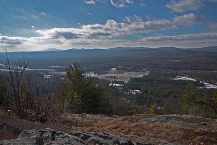
There are a few marked trails through forests. These include the Hedgehog Mt. Ridge trail, from Hedgehog Mt. Rd through to High Five, about 5 miles. This is the longest marked trail in town. Other marked trails are much shorter. They are found in the Deering Audubon Sanctuary on Clement Hill Rd, the Pinnacles on Peter Wood Rd at North Rd., Wilkins-Campbell Forest from Wolf Hill Rd to the Deering Reservoir, the Burke Family Wildlife Preserve on Pleasant Pond Rd near Rt. 149, and a very short trail at the Deering Preserve at Falls Rd, off Old County Rd. The walk from Sky Farm Rd to High Five is along a dirt road and is about 1/3 mile in length. Some people go to High Five for star gazing or viewing the full moon.
With the exception of the Hedgehog Ridge trails, the other marked trails are rather short but are level and ,more or less smooth and fairly easy to walk on.
I have added links to XML files that should enable you to download hiking trails to your Garmin device.
Remember that dogs should be kept on leashes, there should be no fires or camping in Deering’s conserved lands.
