


The longest continuous wetland in Deering extends for about 2 miles from Hedgehog Mt. Rd in the north to just north of the beaver pond in the Deering Preserve. In this wetland there are at least two mighty tupelo trees, and a stand of good-sized balsam fir. Water from part of the wetland flows north in Manselville Brook into the Contoocook River. Water from the southern end of the wetland flows through a small brook into the beaver pond in the Deering Preserve, eventually passing through the Deering Reservoir and into the Piscataquog river.
This wetland is bounded on the west by a ridge that is called Hedgehog Hill or Hedgehog Mt. and on the east by Clark Summit. A recently (2016) completed trail runs along the ridge of Hedgehog Mt from Hedgehog Mt. Rd in the north to Falls Road and then back up to Wilson Hill (High Five) in the south. The total length of the trail is about 5 miles, from Hedgehog Mt. Rd to High Five at Sky Farm Rd.
Getting there: From Hillsborough take Rte. 149 south. After ~1.5 mi bear right on Old County Rd. Follow that for between .6 & .7 mi to Hedgehog Mountain Rd on you right (west). [ For those coming from the south – Hedgehog Mountain Rd is ~3.5 miles north of Sky Farm Rd. / Deering Reservoir Rd off Old County Rd.] Travel about 1/2 mi. to a parking area on the right (north) where there is a SPNHF kiosk with a map. Follow the road past Manselville Brook and up hill for about 1/4 mile to the trail head, just beyond a metal gate on the left. There is also room to park opposite the gate next to the SPNHF Hedgehog Mt. Forest sign.
The Hedgehog Trails pass mainly through land owned by the Society for the Protection of New Hampshire Forests. Two segments pass through privately held land and near Hogden Pasture, where there was logging in 2016, the trail passes through privately owned land. The last part of the trail, coming off Hogden Pasture and Hedgehog Mt. the trail passes through the privately owned Donovan Conservation easement. The town of Deering holds the easement.
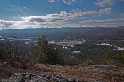
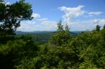
Hedgehog Mountain Overlook Trail is about ¾ mile from the road to the outlook at the top. The beginning of the trail on Hedgehog Mt. Rd is clearly marked with yellow blazes. The first ¼ miles is on a narrow ‘single track’ trail. The next ½ mi. follows an old woods road, with a few detours around seasonally wet areas. (The old woods road is eroded in places and one section just below the peak is very badly washed out due to previous ATV & 4-wheel drive use.) Total elevation gain is ~ 400 feet. There are nice views of the Contoocook River Valley from the outlook at the top. A large part of this trail is steep but a person who is reasonably fit will have no problem with it. The view from the overlook is very rewarding. In early summer the orchid rattlesnake plantain (Goodyeara) is found near the bridge, and among the beech trees on the lower part of the trail there is a lot of the plant Beech Drops, which is parasitic on roots of beech; they look like short, branching twigs growing alongside the trail.
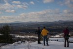
Hedgehog Ridge Trail begins just below the washed out section below Hedgehog Overlook. The trail follows the spine of Hedgehog Mt in a single track trail. The yellow blazes are frequent and easily seen. Follow yellow blazes. The trail is variable in contour. Sometimes level and other times there are steepish ascents or descents through forest. At one point the hiker must scramble over rocks to get to a great overlook, which is also a good spot for lunch! Mostly the trail passes through typical mixed hardwood/hemlock forest. The trail passes below Hogden Pasture, elev about 1300 ft and the second highest point in Deering. Hogden pasture was clearcut by the New England Forest Foundation about 7 years ago, in about 2000 but the vegetation is growing quickly. Thus there are no longer views from the top of Hogden Pasture. The Hedgehog Ridge trail drops down to Falls Rd at the southern end, which it crosses before climbing once again to High Five.
For those wishing to hike south to north or to climb to High Five, parking for at most 2 cars is available on Falls Rd just beyond Beatrice Hunter’s house.
It is possible to make a loop, the Hedgehog Mt. Loop Trail returning to your vehicle on Hedgehog Mt. Download a map of the Hedgehog Mt. Loop Trail to Google Earth. Approximately 2 miles along the Hedgehog Ridge Trail, just beyond an expansive lookout, the trail turns sharply left, toward the north. The trail proceeds about 200 yards and then turns again to the right and uphill. At that point a forest road leading straight north is evident. Following that road, which is marked with red flags, the trail returns to Hedgehog Mt Rd. You will pass through a gate and some distance further along you will be directed to the left. This diversion keeps the trail on Society land and it joins with the Hedgehog Overlook trail near the trail head. The forest road is level once you’ve come off the ridge.
The forest road offers a very good opportunity for snowshoeing and cross country skiing from Hedgehog Mt. Rd.
